
Indicator 6C: Local Control of Land and Ecosystems
- Posted
- Commitments
-

This research was developed in the framework of the ILC-Sheffield collaboration, which is part of a broader ILC internship programme.
By: Yifan Shi
During June and July, 2019 I did research at the International Land Coalition (ILC) in Rome, focusing on LANDex indicator 6C: Local Control of Land and Ecosystems.
This internship placement would form the basis of my post-graduate dissertation at the University of Sheffield. At the heart of my research was understanding the extent to which Indigenous People (IP) and local communities (LC) have secured tenure rights to land and forest in different countries.
Research Method
My research at ILC included two steps.
- The first was to calculate the 6C indicator score for all countries where data was available using the methodology developed for LANDex with the Rights and Resource Initiative (RRI). The methodology for LANDex 6C – based on the RRI Land Tenure Database (2015) and data published in Who Owns the World's Land – includes two elements: an evaluation of the strength of the current legal regime to support secure tenure for Indigenous People and local communities (IPLC) as well as an estimate of the amount of land designated for and owned by these communities. Using this information, the 6C methodology generates a country-level score, set on the 0-100 scale employed by LANDex.
- Once these scores were obtained, I used qualitative methods to determine how these results could support local organizations working to secure the land rights of Indigenous People and local communities.
My research was organized according to the following questions:
- What are the results for LANDex indicator 6C?
- What findings can be drawn from these results?
- When considering the local organisations working on the ground, to what extent can 6C data be used to address the issue and support those working to secure IPLCs tenure rights?
6C Methodology:
The methodology used to derive LANDex 6C incorporates both of the elements listed in the first point above – the strength of the legal regime and the amount of land designated for or owned by IPLCs – in an integrated methodology developed with the RRI.
Based on definitions provided by RRI, the methodology classifies community-based tenure regimes according to the level of control over land possible in the current legal framework. Local control over land is considered to be strong when land is "designated" for IPLCs, meaning that rights-holders have some level of “control” exercised through use, management, and/or exclusion rights over land, they lack the full legal means to secure their claims to those lands. Full "ownership," by contrast, provides IPLCs with full legal rights to their land or forest land. To evaluate the extent of control made possible for IPLCs by the legal regime and the extent to which this control had been realized, we used the scoring system outlined below, with Block 1 and Block 2 – each worth 50 – being eventually combined for a LANDex 6C score ranging from 0 to 100.
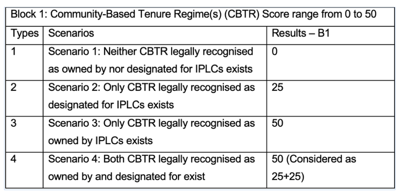
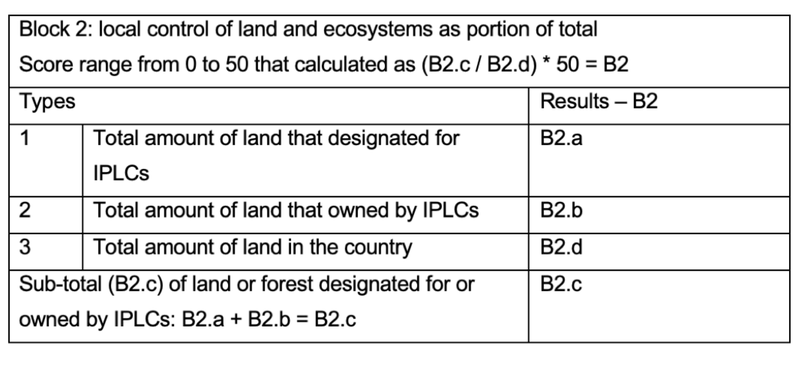
Results were calculated for all countries where RRI Land Tenure Data was available.
Qualitative data:
Based on the results for indicator 6C, I developed a series of semi-structured questions that aimed to better understand how organizations might engage with or use these data while simultaneously collecting feedback for improvement. Members were selected using the ILC online platform MemberNet, which organizes Coalition members according to their work priorities. Forty members were identified for their work on Commitment 6: Locally Managed Ecosystems. Six of these members responded to the request for an interview: the first part of these interviews followed a common format, inquiring about their experience with and use of the data, while the latter part was unstructured and designed to understand the limitations to this data and how it might be improved.
Key Findings
Implementation Gap
As can be observed in the Graph 1, split in two images below, there are clear gaps revealed between local control of land as outlined in the laws and how much land is locally controlled in practice. The disconnection between actual practice and legal stipulations can result in a concern – voiced by many who were interview – related to the so-called "implementation gap."


It is important to reflect on the reasons why good policies do not always translate into good outcomes. In the interviews, there were two dominant perspectives that emerged. The first related to the complex nature of public administration and state institutions, with a great amount of horizontal and vertical bureaucracy present in relevant agencies. The second related to administrative capacity, specifically including: available human resources, financial resources and technical expertise. A lack of resources often means that implementation, as well intentioned or planned as it might be, is not fully – or even partially – realized.
Data availability and the importance of online platform
All representatives interviewed were positive when asked whether or not the data could be useful in their work.
"This data can be useful for us local organisations," commented an interviewed member from Cambodia. "First of all, it provides an alternative data source other than the official one." He went on, adding that "for local organisations in Cambodia, the main data source is from government and if we want to collect our own data, it is required for us to be granted with certifications. Even though there is no universal data can be agreed by everyone, it is still important that local organisations can get access to more voices, the alternative data sources from international NGOs, instead of only government-collected data available."
In this sense, the data collected for indicator 6C and the LANDex platform, more broadly, can serve to support local organisations by improving accessibility to public information. As LANDex is an open-data resource built with the support of a member-led platform but including indicators that employ a wide-range of data sources, it can facilitate dialogue with government agencies and promote the use of a data ecosystem including state institutions, international NGOs and civil-society led efforts.
As to the limitations of this exercise and 6C, in particular, members interviewed said that the data, aggregated at the national level, can fail to represent some local situations adequately. In this sense, while the data may serve to compare the situation of local land control across countries, it would be more useful to local organizations if the data is collected at the lowest level possible. And with this, a recommendation for the improvement of this indicator and the dataset behind it: involve local organizations in the update of this dataset ensuring better data that is more useful to their work objectives.